New accesses to the Mairie des Lilas metro 11 station ![]() Per la versione in Italiano: https://www.stradeeautostrade.it/ferrovie-e-metropolitane/nuovi-accessi-alla-stazione-m11-mairie-des-lilas/
Per la versione in Italiano: https://www.stradeeautostrade.it/ferrovie-e-metropolitane/nuovi-accessi-alla-stazione-m11-mairie-des-lilas/
The extension project of Paris Metro Line 11 towards Rosny-Bois-Perrier included the commissioning of the Line with one more car per trainset (five cars instead of the current four).
This extension involved the adaptation of existing infrastructures to ensure compliance to all present norms and regulations in terms of passenger evacuation.
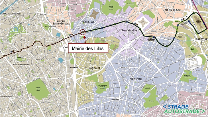
The Mairie des Lilas station is currently the terminus station of Line 11 and it started its service in 1937. It is a station located about 17 m below the Boulevard de la Liberté. The waiting room and hallways are located under the Place du Colonel Fabien.
The station development project involved the construction of two lifts accessible to people with reduced mobility and a new access.
The two lifts are within located in the current main access and constitute the new North and South accesses serving the existing ticket office and, respectively, the platform towards Châtelet and the platform towards Rosny-Bois-Perrier.
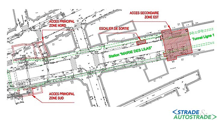
The secondary East access is a new access to the station. This access consists of two fixed stairs that will be at the end of the platform towards Châtelet and at the head of the platform towards Rosny-Bois-Perrier (on the odd-numbered sidewalk of the Boulevard de la Liberté), respectively.
The geological context
The site is located in the Romainville Plateau overlooking the marne River valley towards South, the Seine valley towards South-West and the Plaine Saint-Denis towards North.
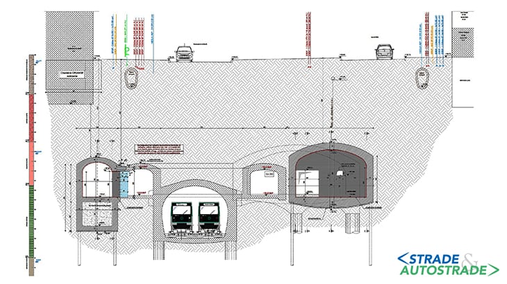
The soil stratigraphy is reported below, from top to bottom:
- anthropic fills: a heterogeneous layer of sands, calcareous blocks, bricks and asphalt. This layer cannot be easily differentiated from the underlying Sables de Fontainebleau. The thickness is about 1,50 m;
- sables de Fontainebleau: fine beige-brown sands found up to a depth of 6,80 m; the thickness is about 3-5 m;
- marnes à Huîtres: greenish-blue-gray clay marls, present between 3,90 and 11,75 m deep. This is the impermeable layer restricting the aquifer of the Sables de Fontainebleau. The thickness is about 4-5 m;
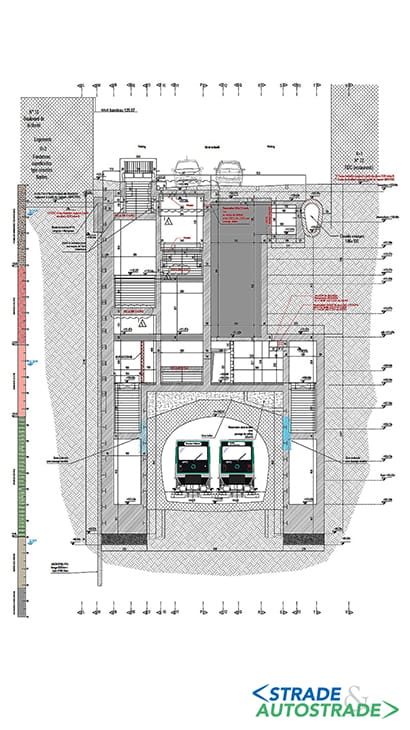
- calcaire de Brie: heterogeneous marly limestones. The thickness is about 4 m;
- argiles Vertes: blue-green marly clay; this is the impermeable layer restricting the aquifer of calcaire de Brie. The thickness is from 7 to 9 m approximately;
- marno-calcaires de Pantin: greenish beige marls with a thickness from 3 to 5 m approximately;
- marnes d’Argenteuil: greenish-grey clays and marls. This is the impermeable layer restricting the aquifer of marno-calcaires de Pantin in the lower part. The thickness is about 10 m;
- masses et Marnes du Gypse: platelet gypsum crystals below the Marnes Supragypseuses.
From a hydrogeological point of view, the following aquifers are present:
- the aquifer in the Sables de Fontainebleau, bounded by the impermeable wall of the Marnes à Huîtres;
- the aquifer in the calcaire de Brie, bounded by the impermeable wall of the Argiles Vertes (also called Marnes Vertes);
- the aquifer in the marno-calcaires de Pantin, bounded by the impermeable wall of the Marnes d’Argenteuil.
The new secondary East access
The secondary East access is located on the odd-numbered sidewalk of the Boulevard de la Liberté. It will provide access with two fixed stairs to the platforms towards Châtelet and towards Rosny-Bois-Perrier. This involved the demolition, on both sides of the tunnel, of the tympanum of the existing station.
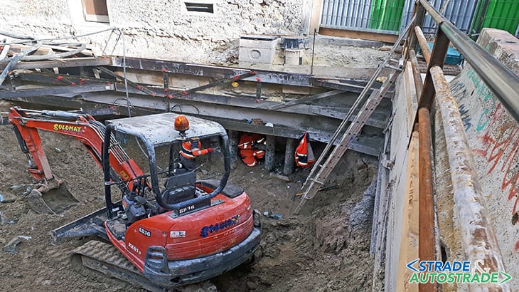
This access was realized partly by means of the “puits blindé” method and partly with conventional tunnels. The surveys carried out at buildings adjacent the structures indicated shallow foundations (mainly continuous footings).
The buildings located at street numbers 11 and 13 of Boulevard de la Liberté (R + 4 and R + 3) were underpinned by a sheet piling connected to a foundation beam. During the execution phase, the excavation method for the East access was revised following the recommendations of the project phase (PRO).
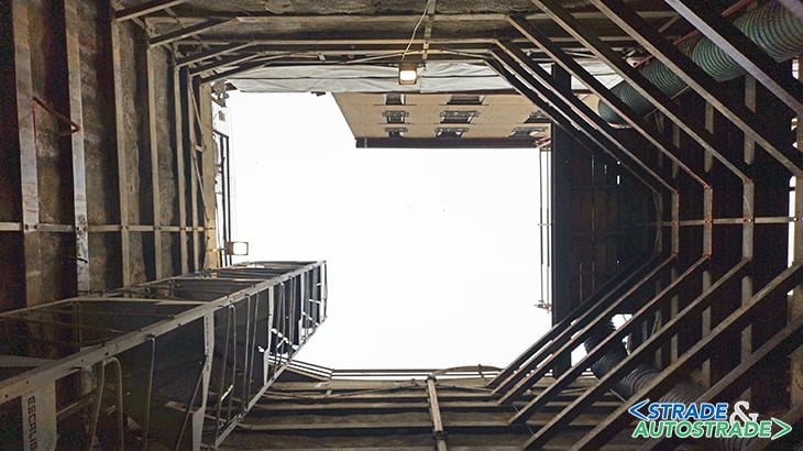
This was possible thanks to the experience gained with the main access works, the North and South accesses, and to a better soil knowledge (www.enser.fr).
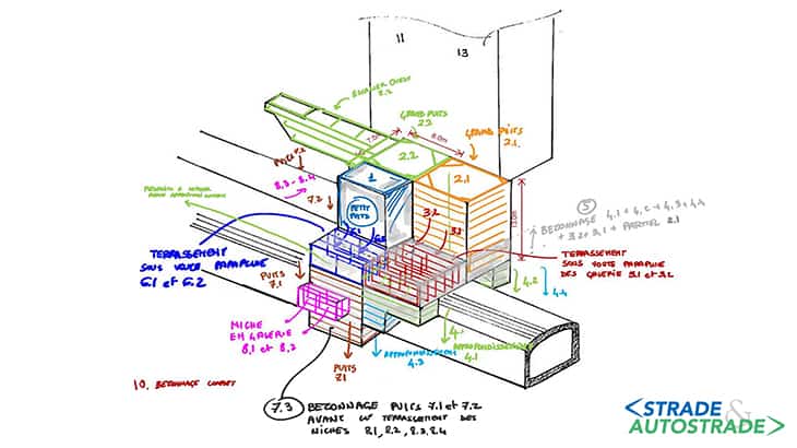
The main idea was to divide the work into three areas. The first area is that of the West stair, quite independent from the rest of the structure and superficial. The second and third areas cover most of the structure and were excavated starting from two access pits, the “Big Pit” 2.1 (GP2.1) from the East area and the “Big Pit” 2.2 from the West area (GP2 .2).
Instead, the excavation started in the second area, with the construction of a pit (“Small Pit” PP) in front of the future access pit GP2.2. This pit was excavated, and its design was completed before the excavation of the GP2.1 and GP2.2 pits.
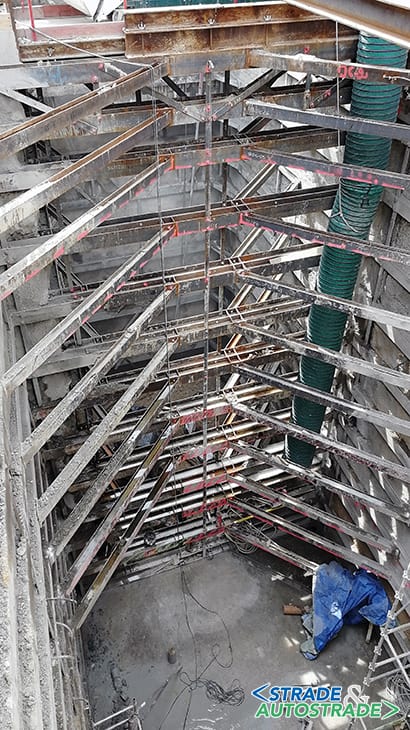
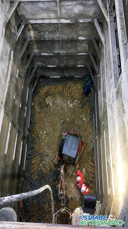
After the construction of the “Small Pit”, the excavation works first concerned the East area, with the excavation of the GP2.1 for a depth of 13 m and 820 m3 of excavated material. At the bottom of the pit, after the realization of a reinforcement frame, tunnel 3 was excavated in two sections of 16.2 m2 surface and 7.5 m length, underneath a sub-horizontal umbrella arch.
At the end of the tunnel, the excavation continued with a deepening of 5.2 m (Deepening 4) on both sides of Line 11 tunnel. The excavation method for the GP2.2 area was similar, except for the excavation of 2 niches during Deepening 7.
3D finite element model
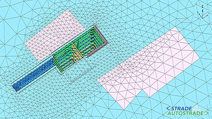
A 3D finite elements model (FEM) has been set up for the planned excavation phases of the Secondary East Access to analyze the effects of works on the existing structures and to validate the construction procedure.
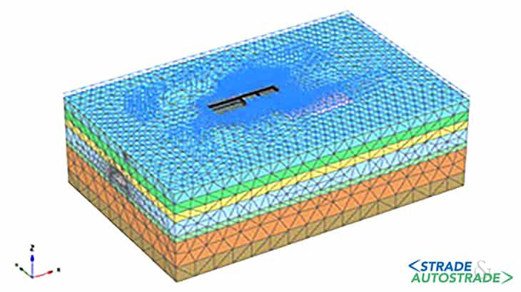
In particular, the displacements in the Mairie des Lilas station, in the Metro Line 11 tunnel, in neighboring buildings and in the road network were evaluated.
An analysis of the stresses on the existing structures was also carried out, as well as a forecast of the settlements and forces expected in the provisional retaining works. The numerical model was created with PLAXIS 3D software.
The domain extends for 140 m in the direction of Line 11 tunnel axis and for 90 m in a perpendicular direction to avoid boundary effects.
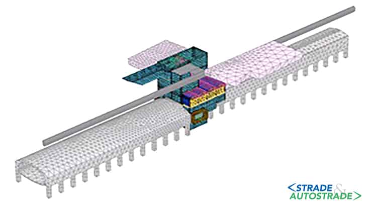
To simulate the behavior of the soil layers, a non-linear elastoplastic law with hardening and Mohr-Coulomb failure criterion (Hardening Soil Model – HSM) was considered.
The monitoring campaign and the comparison between expected and registered settlements
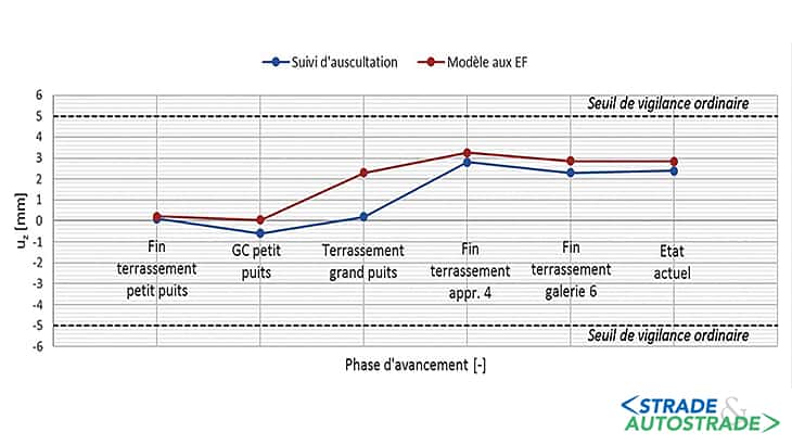
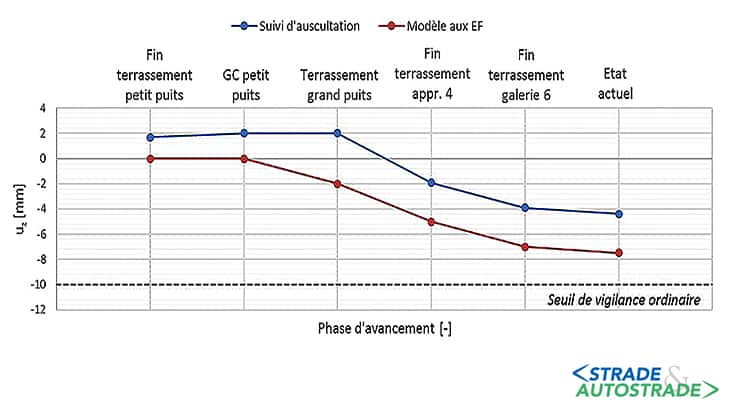
With respect to the tunnel vault settlements, it was possible to make a comparison in terms of centerline uplift at the end of the most important phases.
The pit excavation in phase 1 (Small Pit) generated a slight uplift of the vault and this displacement was compensated by the reinforced concrete coating.
Subsequent excavation works have caused a vault uplift to an extent that is comparable to forecasts. The only main difference was recorded during the excavation of the GP2.1 and GP2.2 pits (“big pits”), where the execution phase deviated further from the modelling phase.
It is also interesting to compare the displacements of the buildings most affected by the project.
In buildings n. 11 and n. 13, located on the North side of the completed works, the measured displacements are not strictly comparable with those predicted by Finite Elements Model.
This was due to the construction of a micro-piles retaining wall for the underpinning of these buildings that was not considered in the numerical model. This choice was made to have a more prudential settlements evaluation, by taking into account that the micro-piles had to be cut for niches excavation.
In any case, the comparison of the settlements is also significant for building n. 24 in Boulevard de la Liberté, which showed the most important displacements during the final excavation works steps.
Overall, the registered settlements were found to be compatible with the defined thresholds. The numerical model, without prejudice to the discrepancies regarding the execution phases and in line with the simplifications taken into account in the modeling, envisaged some displacements that could be compared with the measured values.
Technical data
- Contracting Authority: RATP
- General Contractor: Chantiers Modernes Construction
- Preliminary Design and Project Management: RATP
- Detailed Design: Enser France and Enser Srl
- Contractors of the works: Chantiers Modernes Construction
- Project cost: 12.500.000 Euro
- Duration of the works: 1.200 days
- Submission date: March 31st, 2021
- Completion date: December 2021
![]() Per la versione in Italiano: https://www.stradeeautostrade.it/ferrovie-e-metropolitane/nuovi-accessi-alla-stazione-m11-mairie-des-lilas/
Per la versione in Italiano: https://www.stradeeautostrade.it/ferrovie-e-metropolitane/nuovi-accessi-alla-stazione-m11-mairie-des-lilas/
