Hydrogeological instability: a perennial emergency for roads infrastructures ![]() Per la versione in Italiano: https://www.stradeeautostrade.it/ambiente-e-territorio/dissesto-idrogeologico-emergenza-perenne-per-le-infrastrutture-viarie/
Per la versione in Italiano: https://www.stradeeautostrade.it/ambiente-e-territorio/dissesto-idrogeologico-emergenza-perenne-per-le-infrastrutture-viarie/
The wide term “hydrogeological instability” indicates a complex of phenomena and damages in which the fundamental element for its occurrence is the presence of water, in its liquid or solid forms, and located on the surface or in the subsoil.
Phenomena caused by hydrogeological instability are landslides, floods, coastal erosions, subsidences and avalanches. The phenomenon assumes significant importance in Italy: from ISPRA (2018) data, 7,275 municipalities (91% of the total) are at risk from landslides and/or floods; 1.28 million inhabitants are at risk of landslides and over 6 million inhabitants at risk of floods.
In addition to the cost of human lives, the impact of hydrogeological instability assumes a significant cost in economic terms on the production fabric and its infrastructures.
Historically, the process has had a negative evolution, the causes of which are linked to an underestimation of the problem in a historical context in which anthropization has grown exponentially in the country with the expansion of inhabited centers and related communication infrastructures and at the same time the abandonment of mountain areas: on the other hand, correct territorial planning was not followed.
Certainly the orography of the national territory is penalizing in this respect, given the mountain-hilly prevalence of the Italian territory (about 75%).
The increased environmental sensitivity, and the very serious losses in terms of human lives, have had a legislative effect on the policy of the territory such that modern instruments have finally been applied in order to plan safely in the territory and/or mitigate the areas urbanized and its infrastructure.
If it is true that already in 1989 (Law no. 183 of 18 May) the Basin Authorities re identified, it is with the enactment of Law Decree no. 180 of 11 June 1998, converted into Law 267/1998, which accelerates the identification, perimeter and classification of the areas at risk and hydrogeological risk for landslides and floods, up to he adoption of the Basin Excerpt Plans for the hydrogeological structure (P.A.I.).
Vary authors have concentrated their studies on landslides caused by hydrogeological instability using he two main disciplines involved in the phenomenon, namely eotechnics (soil mechanics and rock mechanics) and hydraulics.
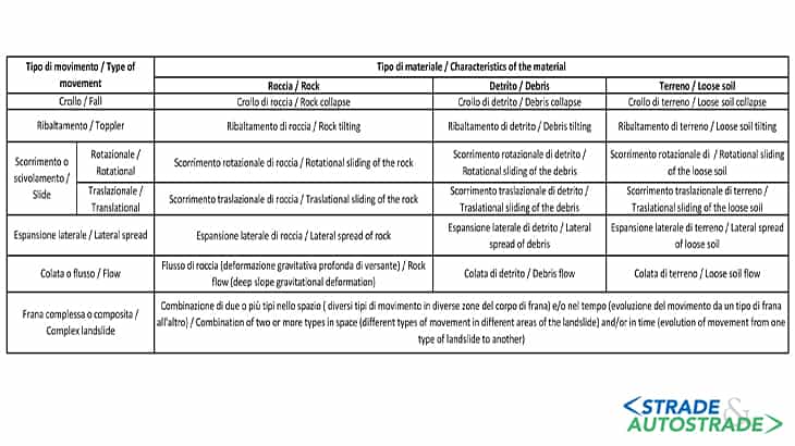
Geology constitutes, as is obvious, the “plot” of the problem: among the dozens of authors, the classification of varnes (1978) and Cruden & Varnes (1996) (Figure 2) seems to be the ost applied for its intuitiveness, but any methodology applied cannot fail to establish in the most reliable way what are the orphometric parameters of the landslides and the probable development of the phenomenon over time, in order to arrive t a potential hazard forecast (and therefore a risk assessment).
In rocky contexts then, the rock mechanics finds its most complete expression with the study of the geological and geotechnical model, where it becomes particularly challenging given the anisotropic, discrete and discontinuous nature of the rock mass.
The reconstruction of all the continuity solutions (joints, diaclases, faults) is of fundamental importance: they are preferential seat of gravitational sliding (provided that the geometric conditions are unfavorable, that is to say “in franapoggio”) by surveing with ropes on the rock side, and/or laser scanners, and the results of which are aimed at one of the numerous numerical analyzes in the static and dynamic field (at present, finite element and discrete element analyzes are widely used).
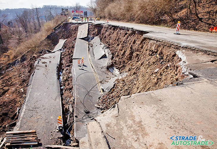
The collapse of the Himera viaduct in Sicily
That the mechanisms that regulate the failures are complex and deeply multidisciplinary demonstrate the events. An example for all is the collapse of the Himera viaduct in Sicily along the A19 motorway between Palermo and Catania: the event of 10th April 2015 involved the sequence of 16-22 piles, six spans, of the motorway viaduct towards Catania involving the closure of the motorway section for 16 km (Figure 3A and 3B).
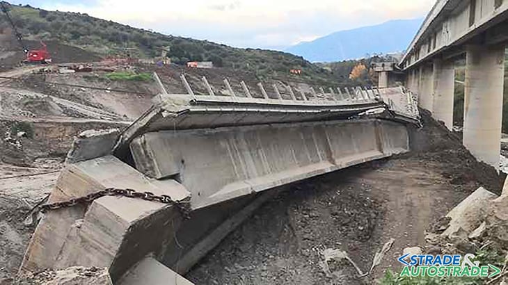
The landslide involves mainly clayey lithotypes, easily modeled and susceptible to gravitational movements. In this case, a decisive action took place according to a surface instability mechanism linked to an erosive action of the alteration blanket of the geological formation in place (Flysch Numidico and Argille Varicolori); groundwater infiltrating the permeable horizons of these geological formations contributed to varying their weight by favoring the formation of preferential sliding surfaces.
The “washout” and “effective infiltration” have therefore played a fundamental role, with both laminar and embryonic runoff action up to an erosion concentrated in already stabilized grooves that tend to progressively deepen to real phenomena of gravitative processes.
The latter degenerating have evolved into rotational and translational flows. The thicknesses concerned do not seem to be high, but have been sufficient to modify the structure of the foundational stacks, in the stretch towards Catania, which they are “supported” by those of the adjacent viaduct.
The combined effects of the exogenous agents were therefore, mainly all the rainfall of a certain intensity and the water emergencies located in the upstream areas (“sources with superimposed permeability”), which generated the imbibition and complete saturation of the alteration blanket which, depending on the existing morphology, is collapsed along the slopes.
The inspections revealed slow leaks of terrigenous masses of the altered blanket (soliflussi-soilcreep) and landslides with different phenomenology.
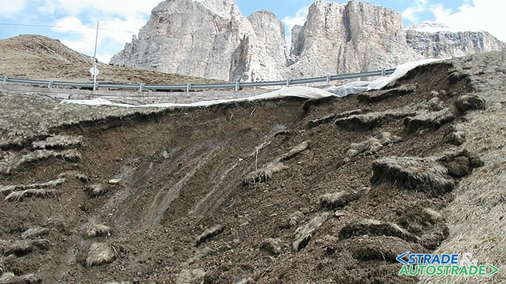
The landslide of Madonna del Monte in Liguria
A similar phenomenon occurred on Sunday 24th November 2019 at approximately 2.00 pm at the motorway section between the Savona interconnection and the “Altare junction” of the Turin-Savona A6 motorway section, where a landslide occurred on a low-susceptibility slope that affected the hill in Madonna del Monte, in the Municipality of Savona (Figure 4).
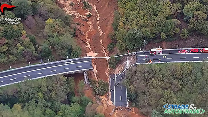
The landslide body reached the bottom of the valley, irreparably damaging the highway viaduct called “Madonna del Monte” and some piles of the adjacent viaduct in the south carriageway, the Rio Valletta, partially blocking the waterway.
The failure mechanism originated initially as a rotational sliding of a portion of the top of the slope, which evolved into a rapid flow of debris and mud due to the high slopes.
The failing area, despite having a water basin area of less than 0.1 km2, has an estimated area of approximately 14,000 m2 and has handled, from the first analyzes, up to 30,000 m3 of material, part of which is still suspended on the slope.
It quickly fell from a height of 300 m along the slope to about 20 m per second, with a devastating impact on the pylons; the first estimates also calculated that another 15.000 m3 of land are in a “quiescent” phase and that therefore they can detach in the future.
The mechanism is originated from the large amount of rain that fell in the previous months causing landslides in an agricultural and abandoned area, before considered to be moderate to low risk.
To the so-called “hydrogeological instability”, wide term are also attributed problems in which Hydraulics and Hydrogeology play predominant roles: Hydraulics and Hydrology contemplate the effects induced on the territory by exceeding critical hydrometric levels (possible flood events) of the water inside the riverbeds, while Hydrogeology reconstructs the interactions and the dynamics between the rainwater of meteoric origin running down on the soil and those infiltrated within it through porosity of the sediment and/or fracturing systems.
A reliable hydraulic and hydrogeological model allows, also in this case as in that of landslides, to hypothesize the occurrence of a flood according to different hypotheses of rainfall regimes and therefore to intervene by correctly designing the hydraulic sections of the bridges, of the defense works, the dimensions of the floodplains, the distances to respect the constraints of building ban along the waterways.
As a corollary of the interventions just mentioned, a virtuous surveillance system (for example through SAR interferometry of the slopes) and maintenance of the territory must be performed, as well as the need for “expert” monitoring of the infrastructures through devices consisting of technicians trained ad hoc for the evaluation of the risk scenarios in a significant context from a geomorphological point of view, with a focus to prevention.
This will allow to act according to the prevention criteria which, if they had been rigorously applied so far, would certainly have led to savings in human lives and economic resources… but that’s another story.
Bibliography
[1]. ANAS SpA – A.A.V.V.: Autostrada A19 Palermo-Catania – ricostruzione della carreggiata dir. Catania del viadotto Himera I tra le pile n° 16 e n° 22”, Progetto preliminare, Nov. 2015.
[2]. A. Trigila, C. Iadanza, M. Bussettini, B. Lastoria – “Dissesto idrogeologico in Italia: pericolosità e indicatori di rischio”, ISPRA (1) Dip. per il Servizio Geologico d’Italia, (2) Dip. per il monitoraggio e la tutela dell’ambiente e per la conservazione della biodiversità, edizione 2018.
[3]. D.M. Cruden, D.J. Varnes – “Landslides: investigation and mitigation”, Chapter 3 – Landslide types and processes, Transportation Research Board special report, vol. 247, 1996.
[4]. Informativa urgente del Ministro delle Infrastrutture e dei Trasporti De Micheli alla Camera dei Deputati sul crollo del viadotto sulla A6 Savona-Torino.
[5]. David M. Cruden, Varnes David J., Landslides – “Investigation and mitigation. Chapter 3 – Landslide types and processes”, Transportation Research Board, special report, vol. 247, 1996.
Hydrogeological instability: a perennial emergency for roads infrastructures ![]() Per la versione in Italiano: https://www.stradeeautostrade.it/ambiente-e-territorio/dissesto-idrogeologico-emergenza-perenne-per-le-infrastrutture-viarie/
Per la versione in Italiano: https://www.stradeeautostrade.it/ambiente-e-territorio/dissesto-idrogeologico-emergenza-perenne-per-le-infrastrutture-viarie/