Safety projects of the S.S. 34 “del Lago Maggiore” ![]() Per la versione in Italiano: https://www.stradeeautostrade.it/ambiente-e-territorio/la-progettazione-per-la-messa-in-sicurezza-della-s-s-34-del-lago-maggiore/
Per la versione in Italiano: https://www.stradeeautostrade.it/ambiente-e-territorio/la-progettazione-per-la-messa-in-sicurezza-della-s-s-34-del-lago-maggiore/
The State Road 34 (S.S. 34) “del Lago Maggiore” represents an artery of primary importance of the road system of the Upper Piedmont and of the Province of Verbano Cusio-Ossola. It starts in the town of Gravellona Toce as an offshoot of the State Road 33 “del Sempione”; it crosses the town of Verbania, and goes back along the shore of Maggiore Lake, crossing the coastal towns of Ghiffa, Oggebbio, Cannero Riviera and Cannobio.
A little more than 4 km North of the town of Cannobio, the road reaches the border with the Swiss Confederation (Canton Ticino), at the international custom of Piaggio Valmara and continues as Strada Cantonale 13, proceeding towards Locarno and Bellinzona, where it meets the road axis connecting the passes of St. Gotthard and St. Bernardino.
As a matter of fact, the S.S. 34 “del Lago Maggiore” has an international interest for the high volume of commercial, tourist and cross-border workers traffic; it represents the only infrastructure serving the western shore of the upper Maggiore Lake, since it is not flanked by any other viability practicable by the current traffic volumes.
From its interruption derive inconveniences and problems not easy to solve that if prolonged in the time can determine important economic damages to the businesses and to the activities of the territory, besides it can negatively affects the international traffic and potentially isolating wide territorial areas of the upper province.
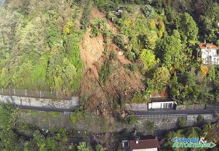
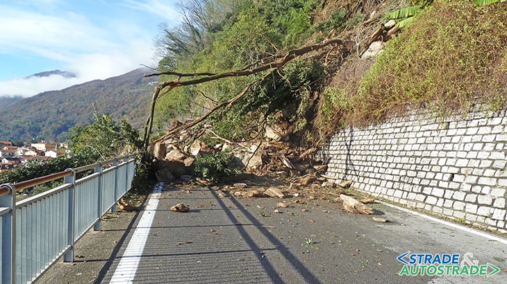
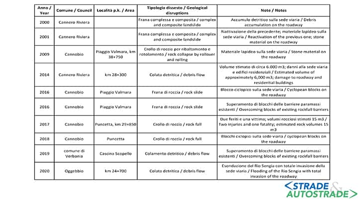
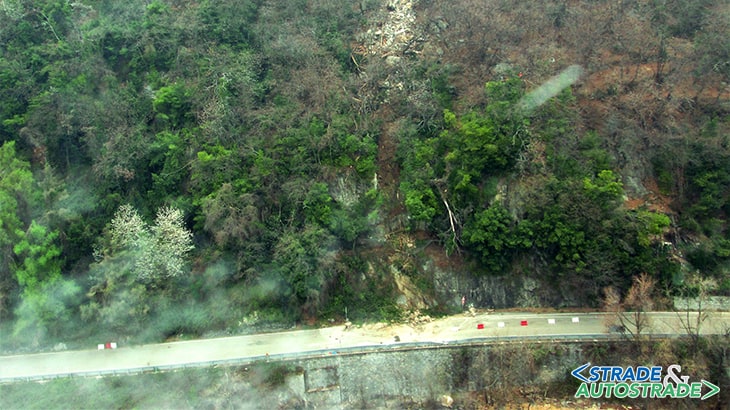
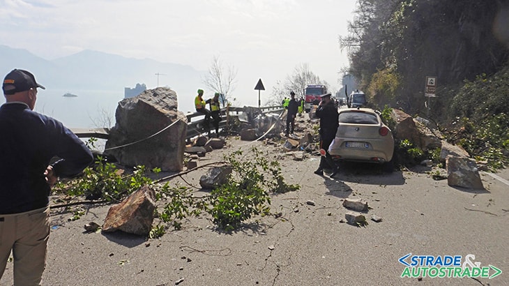
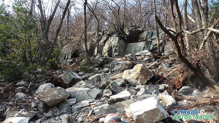
In the last century, there have been major geological disruptions, including the most important in 1977 that occurred just North of Cannero Riviera, consisting of a landslide of soils and rocks pouring in the main road.
In the last 17 years the S.S. 34 “del Lago Maggiore”, due to landslides, mudslides and falling rocks, as well as flooding has been closed to traffic at least a dozen times with the consequences mentioned before.
The most notable events, reported chronologically, are resumed in Figure 2. The territorial authorities, in need to increase the level of safety and wanting to ensure the full usability of the structure, have signed a Program Agreement (D.P.G.R. n. 52 – 09.07.2018), subscribed by the Piedmont Region and the Union of Maggiore Lake (municipalities of Cannobio, Cannero Riviera, Oggebbio and Ghiffa) with the coordination of the municipality of Verbania, having as a general goal the elaboration of surveys, studies and investigation of the geomorphological setting to design and implement all the slope and transit safety projects, excluding some projects carried out directly by ANAS such as the construction of four rockfall protection tunnels.
Relying on these goals, a first assignment has been given to the Polytechnic of Turin (Department of Engineering of Environment, Territory and Infrastructures Laboratory of Photogrammetry, Geomatics and GIS, Resp. Eng. Andrea Maria Lingua) for the acquisition of spatial data, at high resolution in a complex environment, through the integration of techniques/instruments as innovative methods with a multi-resolution and multi-scale approach.
Starting from the results of the general study, the assignments for the technical and economic feasibility studies have been given subdivided into two lots:
- lot 1: maintenance of existing safeguards with replacement and reinforcement of the nets leaning on the rocky escarpments projecting directly on the road, also through overlaps, integrated with nails and diffused ligatures entrusted to the associated Company “Cargnel – Geologia & Ingegneria” in Belluno;
- lot 2A: new slope protection works above the road platform entrusted to the Eng. Stefano Pagani and to the Geol. Massimiliano Coretta (associate Company CMC, Geol. G. Capulli and M. Coretta in Verbania), in cooperation with Geol. Sabrina Casucci and Giovanni Capulli.
The geological study was developed in order to identify the types of instability and then to evaluate the work required to secure the roadway with an initial assessment of costs, starting from the results of the study of the Polytechnic of Turin, which has defined the danger of the areas identifying those most critical, coming to the definition of the interventions necessary to make it safe and starting from Eng. Cargnel’s study that, evaluating the efficiency of existing works and proposing their maintenance (replacement/integration), was considered as the starting point from which design of new works.
Reference was made to existing studies, attributable to other professionals who over the years have drafted and followed safety interventions along S.S. 34; in particular the Geol. Italo Isoli, Francesco D’Elia and Paolo Millemaci.
In the Polytechnic study, 14 areas were identified as the most critical and they have been studied from a cartographic and morpho-structural point of view; four were defined under ANAS competence (identified with the letters H-K-P); therefore the investigations concerned the remaining ten: areas A-B-C (Ghiffa), D (Oggebbio), E-F-G (Cannero Riviera) and J-L-M-N (Cannobio).
For each area a general and geological framework was provided based on existing and new data. Following inspections, an evaluation of the possible scenarios of instability of the slope upstream of the road axis was carried out.
On the basis of the possible scenarios hypothesized, the types of works necessary to make safe the different sections of road divided within each area were indicated.
Where the identification of the types of instability has highlighted the possibility of collapses, the possible mechanisms of detachment and the possible unitary rocky volumes have been identified, verifying the possible trajectories along different sections considered most significant and aimed to identify the potential energy related of the maximum sizing of the protection works.
The data provided by the Polytechnic of Turin were used for the classification of the rock mass rating, integrated with in situ measurements for the definition of the parameters according to the RMR quality index.
Rockfall simulations have been performed with the Colorado RockfallSimulation Program (CRSP 2D), version 4.0, developed by C.L. Jones, J.D. Higgins, R.D. Andrew in 2000, starting from the original version implemented by Pfeiffer (1989) and Pfeiffer et al. (1991, 1995), with the support of the Colorado Department of Transportation, Colorado School of Mines and Colorado Geological Survey.
It is a two-dimensional computational code that allows to consider the shape and the size of the blocks, modeled reproducing results more adherent to the ground evidence, once a proper calibration of the models has been performed.
The assumptions on which the CRSP calculation code is based are:
- rock fall occurs along the most likely path determined based on surveys;
- the worst case scenario is that the largest boulder remains intact along the route; size and shape of the boulder are assumed to be constant for simulations of rock fall from a starting point;
- since the falling boulder does not change en route and the variability of the physical properties of the slope are greater than of the physical properties of the rock material, the coefficients assigned to the slope properties (Rn, Rt) are inclusive of both the characteristics of the slope and the rock material.
The CRSP calculation code requires input parameters:
- slope geometry and boulder size;
- roughness of the slope for each cell (value that is a function of the radius of the boulder and the irregularities of the slope), which alters the angle of impact between the falling boulder and the surface of the slope determining the characteristics of the rebounds of the boulders (Wu, 1984);
- normal restitution coefficients Rn and tangential restitution coefficients Rt for each cell, which quantitatively define the loss of kinetic energy that occurs following each impact due to friction and inelastic components of the impacts. Rn represents a measure of the degree of elasticity of collisions perpendicular to the slope; Rt, on the other hand, is a measure of the attractive resistance of displacements parallel to the slope that reduce the impact energy.
The computational code performs the simulation of rock fall starting from a predetermined starting area with an assigned initial velocity; the velocity components are subjected to the action of gravity acceleration until the fall trajectory intersects the slope profile with velocity Vi.
At each impact the initial velocity, the impact angle, and the rotational velocity are used to calculate the post-impact velocity and rotational components; at each impact point, the slope inclination (ϕ) is varied randomly up to the maximum limit set by the value of the maximum probable change in the local slope angle (ϑmax); this limit is determined from the results of the terrain analysis of the slope surface.
Slope roughness (S) is defined as the variation of the topographic surface perpendicular to the slope over a distance equal to the radius of the design boulder.
This value is important to determine the actual local angle of impact of the boulder on the slope. Slope roughness (S) and boulder radius (R) are used to calculate the maximum possible change in local slope angle (ϑmax).
Conclusions
For each area, relating to the results obtained, the proposals for action have been formulated from which it was possible to draw up the technical and economic feasibility study.
From the study a notebook type of works was developed with the detail of the artifact, the description of the performance level, the methodology of installation and finally the cost per unit through price analysis with reference to the price list of the Piedmont Region ed. 2018.
Altogether 70 interventions have been evaluated, of these 25 are rock fall barriers, one is a rock fall protection tunnel and the rest are cortical coatings and in general slope consolidations.
The set of interventions planned to complete the pre-existing protections, identified in the study of Dr. Cargnel and in addition to the interventions proposed by ANAS, will allow to achieve a satisfactory degree of safety of the important road.
![]() Per la versione in Italiano: https://www.stradeeautostrade.it/ambiente-e-territorio/la-progettazione-per-la-messa-in-sicurezza-della-s-s-34-del-lago-maggiore/
Per la versione in Italiano: https://www.stradeeautostrade.it/ambiente-e-territorio/la-progettazione-per-la-messa-in-sicurezza-della-s-s-34-del-lago-maggiore/